Worst Storm in history tonight..Nuri to gust at 378 kph (235mph)

  Check out the graphic below. Super typhoon Nuri is forecast to hit 314 kph  winds with 378kph gusts tonight/morning at 7.00am. (3rd Nov.)

Then check the Wikipedia entry below. The world record Typhoon Tip was ”only” 305 kph or 190mph.

Luckily there is no land on Nuri’s present track, I wouldn’t fancy being on a boat.

The record ‘Climate Change’ storm should also miss Japan, though with a deviation of just a few degrees it could hit Fukushima while still at hurricane strength.


Sin título

Typhoon Tip

From Wikipedia, the free encyclopedia

Typhoon Tip, known in the Philippines as Typhoon Warling, was the largest and most intense tropical cyclone ever recorded. The nineteenth storm and twelfth typhoon of the 1979 Pacific typhoon season, Tip developed out of a disturbance from the monsoon trough on October 4 near Pohnpei. Initially, a tropical storm to the northwest hindered the development and motion of Tip, though after it tracked farther north Tip was able to intensify. After passing Guam, Tip rapidly intensified and reached peak winds of 305 km/h (190 mph)[nb

This article is about the 1979 typhoon.
Super Typhoon Tip (Warling)
Typhoon (JMA scale)
Category 5 (Saffir–Simpson scale)
Typhoon tip peak.jpg

Typhoon Tip at global peak intensity on October 12, 1979
Formed October 4, 1979
Dissipated October 24, 1979
(Extratropical after October 19, 1979)
Highest winds 10-minute sustained: 260 km/h (160 mph)
1-minute sustained: 305 km/h (190 mph)
Lowest pressure 870 mbar (hPa); 25.69 inHg
(Worldwide record low)
Fatalities 99 total
Areas affected Guam, Japan, Soviet Union
Part of the 1979 Pacific typhoon season

5th May..Climate impact day..Connecting the dots..

inShare1 print

Freak weather is not climate change… up to a point..when it suddenly becomes clear fromn all the evidnce, that runaway climate change is happening.

Finally we can join up the dots.

Thousands worldwide to “connect the dots” between climate change and extreme weather this weekend Anyone and everyone can participate in this day.

Many of us do not live in Texas, the Philippines, or Ethiopia — places deeply affected by climate impacts. For those communities, there are countless ways to stand in solidarity with those on the front-lines of the climate crisis: some people will giving presentations in their communities about how to connect the dots.

Others will do projects to demonstrate what sorts of climate impacts we can expect if the crisis is left unchecked. And still others of us will express our indignation to local media and politicians for failing to connect the dots in their coverage of “natural disasters.”

Jeremy Hance mongabay.com May 03, 2012 Continue reading “5th May..Climate impact day..Connecting the dots..”

Greedy climate politicians trash the World

greedy politicians doom our children

note. posts on NH3 the CO2-Free fuel now have their own blog HERE.. http://co2freefuelexistsnow.wordpress.com/

The latest climate Talks in Durban are set to be an obscene farce as countries vie to be the greediest, stupidest, cruelest and most destructive. We need a revolution NOW, since the Nation States  REFUSE to adopt any reformist solutions, in the name of humanity and the millions of other species threatened with extinction…lets Occupy the Environment

Not content with burying the remains of the Kyoto Protocol the proposal is to  DO NOTHING until at least 2015. Continue reading “Greedy climate politicians trash the World”

North pole webcams fall over as ice melts

Live from the North Pole!

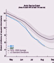
The Arctic lost sea ice very rapidly in the first half of July. Ice loss slowed in late July-early August, but resumed again later in August. Web cam 1 has tipped but not fallen over completely, as you can see in the images.

Web cam 2 fell over on July 23 in the melted snow and ice, and now views only the sky.

Watch the rapid melt in the YouTube video.

web cam image web cam image Latest image from camera 1 Last good image from camera 2. 2011-07-23 01:57:34
Deployment Photo
(April 11, 2011)
Deployment Photo
(April 13, 2011)
Latest image from Camera 1: Aug 25, 2011 12:16 UTC Last good image from Camera 2: Jul 23, 2011

Arctic sea ice is at the crossroads
National Snow and Ice Data CenterAugust 22, 2011

The National Snow and Ice Data Center reports that the average Arctic sea ice extent for July 2011 was the lowest for July in the satellite data record. Ice loss slowed in late July-early August, but Arctic sea ice continues to become thinner and is now declining at a brisk pace.

Further Arctic sea ice loss during the last month of the summer ice-melt season will depend mostly on weather patterns.

With 21 contributors, the August Arctic Sea Ice Outlook projects a September 2011 pan-arctic sea extent median value of 4.6 million square kilometers, below all values seen prior to 2007.